Wednesday, January 30, 2008

Lab 1 Map


The Lab 1 Map I put together is above. It is interesting that some of the "Super Tuesday" states only do one party election on that day (either Democratic or Republican). For the purposes of the map, any state that has any primary activity on "Super Tuesday" has been considered a "Super Tuesday" state. The other states in the legend have already had their primaries. I actually had some trouble exporting the html--it kept "cutting off" the image. I was able to fix this by selecting "Full Document Size" on the jpeg export screen in Flash.

Saturday, January 26, 2008

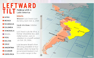
Interesting Political Map


This is a fascinating interactive map put together by MSNBC detailing the political situation in Latin America. One can click on a particular country to receive a brief profile of the country's current leader, the election history, and his/her political platform. The main purpose of this map is to show how there as been a leftward political shift in the region. Some of the countries displayed are not interactive, perhaps because data is missing or because the leftward shift has not occurred in these countries. However, the designers have effectively marked the countries that are non-interactive by graying them out so that they cannot be clicked. This is a great interactive and graphical way to keep track of current events in Latin America. A screenshot of the map, with Brazil "clicked" is shown above. To obtain the true effect of this map, it is best to visit the link above.

About my links

http://imagesearch.geoeye.com. This is a satellite imagery archive search site that allows you to see what satellite imagery GeoEye has collected over specific areas. It is designed to show what imagery is available for purchase, but its detailed base map and low-resolution image samples allow you to easily see a snapshot of what the area looks like both on a map and as a satellite image.

http://www.lib.utexas.edu/maps/. This is a website for the map collection available at the University of Texas Austin. They offer a wide range of free downloadable political, physical, and thematic maps for locations around the world.

http://www.mapquest.com/. This is a great site for actually using maps as a travel planner. In addition to being able to provide free maps of a specific area, it also includes a detailed driving directions between two points and a gas prices database based on location. I use this site every time I am planning a trip.

Wednesday, January 23, 2008

Hi! Welcome to my Map Design course Blog! This is my first time blogging, so it is a work in progress and will hopefully improve as I go along. Enjoy!